The first time I did this trail was 2 years ago and it took a group of about 12 of us 12+ hours to finish. We hit the trailhead at 5:30 am; I was the first one down from the trail and I walked to my car at close to 6:00 pm. I was one of the only ones to make it out while we still had sunlight. The bulk of the group finished the trail in the dark. As you look at the pictures (or if you've ever been on the Flatiron/Siphon Draw trail) - you'll see (or know) that's not a good idea. Also, it was mid October and hotter than blazes (I think it got over 100 that day).
This time around things were much different. We had a group of 14 of us going across east to west, and another group of 5 going west to east (It's definitely a one-way trip so we shuttle cars and/or exchange car keys on the trail). We hit the trailhead at 7:00 - which was some cause for concern. As I said, the last time we did this it took 12 hours, so we were thinking we would have to make some serious time on the trail to avoid having to hike in the dark. I'm normally a very strong and fast hiker, so I took off with the advance group (5 of us - cutting a wicked pace).
I needn't have worried about making time up. We were being led by a gentleman named Steve who's reported normal time across the trail is 5 hours. Dude is a freaking machine. We finished in just over 7 hours. From all reports the rest of the group were down from the trail by 5:00 or so - about 2 hours behind us. A far cry from the 12+ hours it took us 2 years ago.
The day was just spectacular. The sky was clear, it was cool (I think it may have hit 80 or so) and there was just enough of a breeze to cool you off quickly if you stopped (which we didn't do a lot).
Overall a fantastic day of hiking.
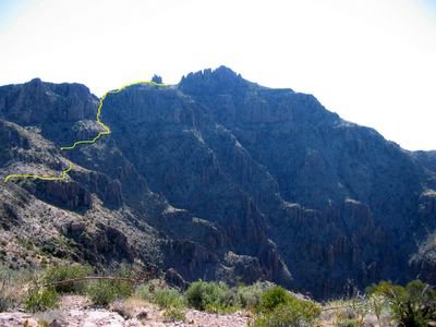
The following pictures don't nearly do justice to the scale of the hike, and in fact the distances as they appear in the pictures are a little deceiving - it is truly a long hike. I have also added a tracer to show approximately the route of the trail - it disappears as it goes behind objects.
For those who have read earlier posts, I've changed format and am now putting the captions for the photos above the pictures. Based on the way that Blogger.com formats stuff, it just looks better that way (in my opinion).
Below is a shot from where we parked our cars at the Carney Springs trailhead - it's about 7:00 am.

After an insane ascent - truly, you have no idea - you reach the first saddle and get this view looking back eastward. The cars down at the bottom are actually campers that were near the trailhead, but we were only about 1/4 mile to the south and west of them around the face of the cliff in the picture.

This shot is looking west toward Superstition peak from that same saddle. That's NOT the halfway point either - more like the 1/3 point of the hike.

We actually missed the peak and skirted to a saddle between the peak and a lower set of hoodoos - to backtrack and hit the peak itself would have taken too long, and all of us had been on top before, so we decided to skip it. This shot is looking east away from the peak looking towards the Flatiron area.

You do some pretty interesting and difficult climbs getting off of the peak, and looking back it's sort of hard to tell exactly how you did it. Even with the trail marked it still doesn't look safe.

Here we are near the "end" - really just nearing the familiar territory that is the Flatiron/Siphon Draw trail. Looking back over the way we came, that peak way back there is Superstition peak. We're about 3/4 of the way through the hike at this point.

Ahh...the familiar site of the insane descent that is the Flatiron/Siphon Draw trail. Keep in mind that you've already hiked nearly 9 miles and your legs are feeling like jell-o - and that descent is no picknick even if you're fresh.
Good times.

Finally, we're down at the end of the Siphon Draw trailhead and entering the home stretch - no more steep downhill climbs, just sliding along all the loose rock and gravel for another mile or so.
Did I mention that your legs feel like jell-o at this point?
That arrow is pointing to the campground area - our final destination.

That's what we just did. Well, that's the Flatiron/Siphon Draw trail anyway - the rest of the trail is all behind the mountain.
Finally I can enjoy the ice-cold Gatorade from the cooler in my car. Thankfully we had a wonderful support crew that came and picked us up and drove us back from the trailhead the last 1/4 mile or so to the campsite.
Like I said - a fine day of hiking.

This is a panorama view from just below the peak looking north and sweeping east.

Another panorama view from just before the final stretch looking north and sweeping east. You can spot Weaver's Needle in both panoramas if you know what to look for - it sure doesn't look the same from the backside.

It will take me at least 1 week to recover from this hike, but it's totally worth it.

No comments:
Post a Comment